If you are planning to relocate to Miami, you are
not alone. Miami-Dade County, also known as "Metro-Dade
County", has experienced a 20 percent growth in population
over the last ten years, much of it from recent immigrants.
The county now contains the second largest percentage
of foreign-born residents in the United States. While
the City of Miami boasts the largest population, many
new residents choose to live outside the city, in surrounding
municipalities and unincorporated areas of the County.
Below is a guide to some of these neighborhoods.
Miami: Facts
Population:
400,000. 65% Latino. Miami is the largest city in Miami-Dade County and a city
of extremes: spectacular wealth living side by side
with dire poverty. It is both a bustling international
financial mecca and a hotbed of Latin music and culture
that is sweeping America. Originally a town of white
Southern farmers and businessmen, Miami is less a "melting
pot" than a sometimes uneasy co-existence of unique
cultures and customs: white, African-American, Latino,
Haitian, Jewish. In the past racial tensions have boiled
over into violence, such as the Liberty City riots.
Miami
Neighborhoods:
Allapattah
- one of Miami's poorest neighborhoods
Location:
NW 7th-27th Avenue between 20-38th Streets near Miami
Civic Center and Jackson Memorial Hospital
70%
Hispanic
Special
features:
-
Wholesale
produce market
-
Clothing
outlet district
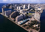 Brickell
Avenue: the banking and business center of Miami.
Upscale condos, hotels and dining establishments serve
a growing residential population of bankers and executives
who want to live near their place of work. Brickell
Avenue: the banking and business center of Miami.
Upscale condos, hotels and dining establishments serve
a growing residential population of bankers and executives
who want to live near their place of work.
Location:
South of the Miami River
 Downtown Miami - the heart of Miami, centered at
Flagler Street and Miami Avenue. Miami's streets are
labeled according to their relation to this main intersection
(eg NW, NE, SW and SE). For example, E 1st Avenue is
one block east of Miami Avenue. (See Map) Downtown Miami - the heart of Miami, centered at
Flagler Street and Miami Avenue. Miami's streets are
labeled according to their relation to this main intersection
(eg NW, NE, SW and SE). For example, E 1st Avenue is
one block east of Miami Avenue. (See Map)
Tip:
Miami streets run east and west, while avenues run north
and south. (exceptions: Hialeah and Coral Gables)
Downtown
Miami is a highly commercial area with many electronics
stores.
Sights:
El
Portal
Pop:
2500
Location:
between Little Haiti and Miami Shores
Older
single-family homes with tree-lined streets. Large Haitian
and Hispanic population. Over 1/3 of the residents are
foreign-born. Three subdivisions: El Jardin, Sherwood
Forest, El Portal. Contains the site of an ancient Sequesta
Indian burial mound.
Little
Haiti - NE 54th between Biscayne Blvd. and N Miami
Avenue - Creole-speaking community with interesting
Haitian stores and spiritual shops.
Little
Havana
Location:
west of Brickell Avenue
A
vibrant latin neighborhood, home to residents from Cuba,
Honduras and Nicaragua. At its heart is Calle Ocho,
lined with authentic Cuban businesses like cigar factories,
fruit stands and cafeterias. Here you can find chicharones,
merenguitos and other Cuban treats, plus memorabilia
shops, galleries and theatres.
Special
Events:
-
Calle
Ocho Street Fair (March) site of Miami's Carnival
-
Cultural
Fridays (last friday of each month) art, music, dance,
theater and poetry performances on Calle Ocho.
Liberty
City - an economically depressed African-American
community
Location:
NW 12-19th St, between 62-73rd Street.
Home
of the African Heritage Cultural Arts Center, with a
theatre, art gallery, dance and music studio.
Miami
Shores
Chamber of Commerce website: http://www.miamishores.com/
Described
as "the poor man's Coral Gables," Miami Shores
is a small bedroom community of 10,000 with a small-town
feel. 14% Hispanic.
Nearby
Grove Isle Schools and Universities:
Overtown
- one of Miami's poorest communities with mostly public
housing. This African-American neighborhood is currently
undergoing restoration.
Beaches
and East:
Aventura
Pop:
20,000
Affluent
condo and housing development community with large
Jewish population. Growing population of young families.
Sights:
Bal
Harbour - the most exclusive of all Miami
communities. Home to celebrities and millionaires,
luxury resorts and couture shops (Bal
Harbour Shops).
Bay
Harbor Islands
Pop:
4703
20%
Hispanic
A
quiet residential island near Bal Harbour. Mostly
retirees and working professionals.
Beaches
nearby. Low crime rate.
Coral
Gables
Pop: 42,249
Hispanic pop: 42%
Founded
in 1925, Coral Gables was born into elegance and
promptly nicknamed "The City Beautiful".
Many Mediterranean-style fountains, plazas and buildings
grace its boulevards. Mostly a manicured, upscale
Miami suburb, it is home to a booming Hispanic population
in North Gables.
Sights:
the historic Biltmore
Hotel, many chic restaurants and cafes, "Miracle
Mile" (the upscale shopping district), the
Venetian
Pool, Fairchild
Tropical Gardens and the University
of Miami. Also historical villages: Chinese
Village and French Normandy Village.
 Coconut
Grove Coconut
Grove
A
former bohemian village, "the Grove" is
a trendy upscale neighborhood with shops, cafes
and a carnival-like nightlife atmosphere. The city
is a mix of condo communities (Grove Isle) and expensive
single-family homes.
Sights:
Golden
Beach
Pop: 852
A tiny and exclusive gated community of single-family
homes and nearly non-existent crime. Miami-Dade's
northernmost beachfront community.
Key
Biscayne
Pop:
8,800
A
small exclusive island enclave with many foreigners
and retirees. Condo communities and single-family homes.
Connected to Miami via the Rickenbacker Causeway.
 Miami
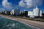
Beach Miami
Beach
Location:
43rd to 96th Street on the Ocean.
(not
to be confused with North Miami Beach on the mainland)
An
older neighborhood with a large population of retirees.
High rise condos and luxury hotels in the east, single
family homes in the west.
Sights:
North
Bay Village
Small
island community linked to Miami Beach via the 79th
Street Causeway
Over
1/3 Hispanic
North
Miami Beach
Pop:
35,270
Location:
I-95 and the Intracoastal Waterway between North Miami
(NE 151st St) and Miami-Dade County
A
city of eighteen neighborhoods in NE Miami-Dade county.
Originally a haven for Jewish retirees from the Northeast
US, now experiencing growing Chinese and Caribbean populations.
Many Jewish synagogues and bagel shops. Local library
has extensive Spanish and Chinese collections.
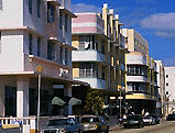
 South
Beach South
Beach
South
Beach is the world-famous tourist and style mecca
immortalized in film and modeling shoots. Chic beach
clubs, nightclubs, boutiques and fancy eateries.
In the Art Deco district over 800 vintage hotels have
been renovated to the their original pastel palette
of pinks, corals and blues and embellished with neon.
Residents are an eclectic mix of subcultures. Upscale
neighborhood.
Location:
5th - 21st st. on the Atlantic Ocean
Sights:
-
 Lincoln
Road Mall - a chic and popular pedestrian-only outdoor
shopping district with boutiques, bookstores, art
galleries and studios. Lincoln
Road Mall - a chic and popular pedestrian-only outdoor
shopping district with boutiques, bookstores, art
galleries and studios.
-
Washington
Avenue - hottest nightclubs
-
Ocean
Drive - cafes and condos
-
Collins
Avenue - chic specialty shops and Art Deco hotels.
-
Art
Deco District - Lincoln Rd. to 6th St. betw. Ocean
Drive and Alton
-
Espanola
Way - charming spanish-style village of nightclubs,
restaurants and shops. Home to historic Clay
Hotel and International Hostel.
Sunny
Isles
Pop:
13,500
A
small community of condos and housing developments populated
by retirees and winter residents.
Housing
developments: Atlantic Isles, Golden Shores
NY
style deli: Rascals
Surfside
Pop:
4100 small but growing oceanside community between Miami
Beach and Bal Harbour. Retirees and young professional
families. Elementary school, movie theater, parks,
Bal Harbour shops and the ocean all within walking distance.
Brownsville
Middle-class
mostly African-American neighborhood.
Bunche
Park
NW 22nd ave. from Opa-Locka on the south to Palmetto
Expy. on the north.
A low-income African-American district.
Carol
City
Pop:
53,000
Location:
NW 17th-57th betw. Palmetto Expy and County Line Rd.
An
ethnically diverse lower-middle class community with
a growing Hispanic presence.
Sights:
-
183rd
Street Flea market
-
Pro
Player Stadium (formerly Joe Robbie Stadium)
- home of the Miami Dolphins football team
Doral
Pop:
14,000
A
manicured suburban enclave with a growing population.
Headquarters for large US companies like Univision,
Carnival Cruise Lines and Ryder.
Location:
NW of Miami near Miami
International Airport
 Hialeah Hialeah
Pop:
213,000
A
densely populated Spanish-speaking community of Cubans
and other Latin Americans. Street signs and billboards
are in Spanish. The commercial district contains many
Latin cafeterias, tabacco shops and supermarkets.
Home to Hialeah Park Race Track and the Westlands
Mall.
Sights:
-
Hialeah
Park Race Track - famous S. Florida landmark,
home to thoroughbred and dog racing. Also site of
a wildlife park with its signature flock of wading
flamingoes.
-
Hialeah
SpringFest (February at Hialeah Park) - a weeklong
festival with local artists and live Latin music,
food and carnival rides.
-
River
Cities Festival (April at Hialeah Park) - Carnival
rides, food, local arts and crafts displays.
-
Singing
for Seminola (February) - Local gospel and African-American
folklore
-
Jose
Marti parade (January) - celebrates the birth
of the Cuban patriot
Hialeah
Gardens
Pop: 19,297
Latino community west of Hialeah.
International
airport anchors this area with hotels and office
complexes quickly dotting the landscape.
Nearby
communities include Doral and Miami Springs.
Sights:
Miami
Lakes
Pop:
23,000
Location:
bounded by the Palmetto Expressway on N and W, betw.
NW 57th and 138th streets
A
quiet planned community with lots of lakes, parks
and golf courses. Mostly white and Hispanic middle-class.
Main Street is a quaint downtown shopping district
with old-fashioned charm.
Festivals:
-
Mother's
Day Arts and Crafts Festival (Mother's Day Weekend)
-
Latin
Jazz Festival (September)
-
Spring
Festival, Our Lady of the Lakes Catholic Church
Miami
Springs
Pop:
13,343
40%
Hispanic
Location:
between Hialeah and Miami
International Airport
A
quiet family community which enjoys an old-fashioned
small town Americana feel. Fourth of July parades, a
scenic gazebo, Olympic-sized public swimming pool.
North
Miami
Pop:
50,258
24%
Hispanic
Racially
diverse suburban community with a booming population
of young families. Growing Hispanic contingent.
NE 125th Street downtown area is undergoing redevelopment.
Westside:
Caribbean neighborhood.
Sights:
Opa-Locka
Pop: 17,000
One of the poorest communities in Miami-Dade County,
opa-locka is known for its airport and for housing
the largest collection of Moorish architecture in
the Western Hemisphere. A program to revitalize the
downtown area is currently underway.
Sweetwater
- a small town with mostly foreign-born Hispanic presence.
Main language spoken is Spanish. Sedanos supermarket
and Los Ranchos restaurant are the local landmarks.
West
Miami
Location: west of Coral Gables
Pop: 5,863
60% Hispanic
Mostly residential area near Coral Gables. Coral Way
and SW 8th St. betw. 57th and 67th St.
South
Country
Club of Miami
Between Miami Lakes and Broward County line
A partially-gated planned community of single-family
homes. A mix of year-round residents and winter retirees.
Features two 18-hole golf courses, lakes, a swimming
pool and a clubhouse/restaurant.
Cutler
Ridge
Former agricultural area with growing population of
young families. Main commercial sub for S. Dade centered
at 168th St. and Biscayne Bay. Favored for its gated
housing developments and proximity to Biscayne Bay.
Cons: Located near the S. Miami-Dade landfill "Mt.
Trashmore."
Florida
City
Pop: 7,843
Southernmost municipality in Dade County. Businesses
and homes are being rebuilt after Hurricane Andrew damaged
the area. Home to the Florida Keys Outlet Mall, hotels
and businesses. Large agricultural presence and wholesale
Farmer's Market.
 Everglades
National Park - a vast 1.5 million-acre wetlands
preserve and wildlife conservation area. Largest wilderness
in the US east of the Mississippi River. Mangrove forests
and cypress swamps shelter alligators, storks and other
wading birds as well as a great variety of marine life. Everglades
National Park - a vast 1.5 million-acre wetlands
preserve and wildlife conservation area. Largest wilderness
in the US east of the Mississippi River. Mangrove forests
and cypress swamps shelter alligators, storks and other
wading birds as well as a great variety of marine life.
Less
than an hour's drive from Miami.
Homestead
A
rural community at the south end of Dade County 30 miles
south of Miami. Destroyed in 1992 by Hurricane Andrew,
this is a community in recovery. Former Air Force Base
may become a commercial airport but is opposed by environmental
groups due to its proximity to the Everglades National
Park, Florida's largest wilderness preserve.
Kendall
Location:
Dixie Highway to the Florida Turnpike betw. Sunset Drive
and 104th Avenue
A
large bustling suburban middle-class community that
has experienced explosive growth in recent years.
A
popular place to raise a family. Traffic and schools
are overcrowded.
Leisure
City - Planned community of single-family homes
24 miles south of Miami. Originally a retirement community,
it sustained severe damage during Hurricane Andrew.
Agricultural workers are now moving into this area.
Medley
Pop. 868
Small business/residential community across the Okeechobee
River from Hialeah. Home to the River Cities Festival.
Pinecrest
Pop: 15,378
A well-heeled residential community with relatively
low crime rate. Location: SW 136th St betw Old Dixie
Highway and Cutler Rd.
Virginia Gardens
Pop: 2,348
Between Miami Springs and Miami International Airport.
The town was incorporated by disgruntled Miami Springs
residents after horses were banned from the city.
|